General
-
Architecture
- Each block (unless specifically designed otherwise) represents a European style super-building akin to the block in Prague shown below.
- Mixed use
- No setbacks
- Large central courtyard for green space and leisure space.
- 6 story height maximum.
- Example

- Each block (unless specifically designed otherwise) represents a European style super-building akin to the block in Prague shown below.
- Private automobiles are completely banned.
- Cul-de-sac avoided as much as possible
- Prioritize connectivity of Streets
- Major arteries try to go as direct and completely between major nodes
- Try to make all routes into one continuous road rather than multiple roads
- Example (Their “bad” is what I consider good)

- Try to make all routes into one continuous road rather than multiple roads
Boston
- In a move to standardize all primary arteries are 20 meters wide by default
Boston
- Downtown
- Pre-urban-renewal streets restored.
- Beacon Street extended to Scollay Square
- Western Hanover Street rerouted through old Sudbury Street to connect with Scollay Square in more nodal way.
- Summer Street expanded to Bowdoin Street to connect with Bowdoin Square
- Downtown Square
- Old European style plaza as the definitive city center of Boston
- Downtown Square expanded to connect with State Street/Old State House
- Faneuil Hall Market expanded and adjusted to perfectly align with the center of Faneuil Hall
- Downtown transit hub connecting tram lines, subway lines and train station on North-South rail connector
- South Station
- Expanded even beyond old South Station site.
 |
|---|
| Downtown Boston |
 |
| Downtown Boston overlay comparison |
 |
| Downtown Boston as it stands today |
- Back Bay
 |
|---|
| Back Bay |
 |
| Back Bay as it stands today |
 |
| Back Bay overlay comparison |
 |
|---|
| Columbus Park |
 |
| Columbus Park as it stands today |
 |
| Columbus Park overlay comparison |
 |
|---|
| Downtown Boston Faneuil Square |
 |
| Downtown Boston Faneuil Square as it stands today |
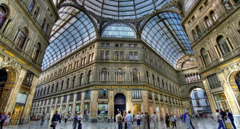
- Prudential Center/Hynes Convention Center turned into one giant pedestrian mall building with covered streets similar to Galleria Umberto I in Naples or the old Les Halles in Paris.
 |
|---|
 |
|---|
- Infill for the trainyard that lay beneath it.
- Hereford Street moved west to extend Dalton Street and maintain similar length x width ratio of other neighboring blocks
- Hemenway Street restored to go all the way to Commonwealth Avenue.
- Dartmouth Street extended across the Charles by a new bridge to connect with Kendall Square in Cambridge.
- Columbus Avenue and Huntington Avenue made perfectly parallel and perpendicular streets organized into a more coherent grid.
- Southwest Corridor trainline made to be perfectly in the center of Huntington Avenue and Columbus Avenue.
- Southwest Corridor Park organized into a uniform path.
- Streets near Westland Avenue organized into a more coherent grid that is symmetrical with Westland Avenue as their axis.
- Trinity Church moved to be out of the way of Huntington Avenue’s right of way.
- Storrow Lagoon removed to keep the river front uniform.
- Fenway-Kenmore
- Grid of Back Bay extended into Fenway-Kenmore
- Brookline Ave rerouted to South Huntington Ave
- Storrow Drive removed and replaced with waterfront path and the blocks facing it are expanded to the dimensions of the other blocks in the area and are able to actually face the waterfront.
- Train line adjusted to be perpendicular with Charlesgate and in the center of Landsdowne Street and Newbury Street
- Back Bay Fens
- Back Bay Fens expanded.
- Westland Gate adjusted to be a symmetrical curved opening.
- Bowker Overpass and other superfluous roads removed.
- After reaching Boylston Street the Muddy River is centered within Charlesgate and stylized with lagoons reminiscent of the now removed Storrow Lagoon included a delightful circle/plaza at its intersection with Commonwealth Ave.
- Brookline Avenue removed.
- Boylston Street rerouted to head along similar path of Brookline Avenue but instead connect down to South Huntington Avenue.
- Van Ness Street adjusted to align perfectly with eastern Newbury Street.
East Boston


Waltham
- General
- Beaver Brook has been resurfaced and turned into a uniform canalized parkway similar to Cheesecake Brook.


Downtown
- The streets that surround the common are realigned to be perfectly perpendicular.
- The Common is redone in a neoclassical/baroque design emphasizing symmetry and continuity with approaching roads.
- Town hall is moved to center of the Common to emphasize symmetry.
- Sightline of Lexington Street leads directly to the center of the front face of the town hall.
- Train line is double tracked and as a result so is the station.
- The Outbound Commuter Rail Station has been consolidated into the double tracked station near The Common.
- St. Mary Church is made to be centered in a plaza in more European style.
Cedarwood
- Followed the average arc of the radial roads of Cedarwood neighborhood and create a big neoclassical radial grid surrounding and mixing in with the street.
- Even Weston St, which is independent, tastefully mixes in and out of line with radial grid as passes through.
Brandeis
-
Brandeis mixes in with the radial plan of Cedarwood.
-
Even the train line’s curve is made to follow the curve of Cedarwood’s radial plan.
-
The Theatre turned out to be the center of the circle (purely by coincidence too or at least it was close enough that it didn’t need to be moved far).
-
Campus is expanded with new buildings added.
-
Larger Loop rd that blends in and out of mix with the radial grid.
-
Water tower is emphasized and turned into a rotary/plaza connected to Loop rd
-
Old South St reshaped to into two perfect semi-circles that blend in and out of mix with the radial grid.
-
Main Entrance is made symmetrical with main path a straight main path cutting through the center to
-
Bentley
- Bentley no longer exists.
- Partially due to it geographically being in the nature reserve and partially due to its promulgation of Hitlerian sciences.
- Southern campus converted into park.
-
Banks Square
- Banks Square turned into an actual plaza instead of an intersection
- Becomes a transit hub of tram lines.
- Maple street connects to South Street to make the artery connect directly to Banks Square.
- Something similar was planned and almost done in real life.
- Radial grid tastefully mixes in with edges of Banks Square especially to form border with Brandeis
- Prospect St follows a potential plan for its design and connects with South st at the intersection of Main and Weston to form an emphasized node/plaza.
- Nipper Maher Park is slightly expanded.
- Riverview Station is revived.
-
Prospect Park
- Prospect Park is expanded to Winter Street on the North.
- Bear Hill Road is adjusted to connect to Wyman Street and the intersection of Main Street and Stow Street.
- Bear Hill Road becomes the western bounds of Prospect Park.
- The hill was never excavated along Border Road and maintained its natural topography.
- Summit Avenue is extended from Cedarwood to serve as the eastern bounds of Prospect Park by following the topography of the mountain to keep all relatively flat areas as part of the city and the hilly sections are ceded to Prospect Park.
- Totten Pond Road no longer exists and wasn’t excavated from the hill.
- The ski slope is reopened and extended to the peak.
- The chairlift and ski slope is expanded to the south so that it connects to the train station on the south for ease of access.
Brookline
- Beacon Street retains same trajectory is it had in back bay, cutting a straight line through Brookline.
Allston
- Brighton Avenue adjusted so it remains centered with its connection to Commonwealth Avenue.
- Train line adjusted to be perfectly parallel with Brighton Avenue and then parallel with the riverfront near the Magazine Street Bridge.
- Boston Landing train station replaced by Allston Station near the intersection of Harvard Avenue and Cambridge Street.
- North Harvard Street connected to Harvard Avenue by widening Franklin Street in order to serve as artery from Harvard Square to Coolidge Corner.
- Harvard School of Economic Planning Campus
- Circular design systematized.
- “The March” runs a straight line from Cambridge’s Longfellow Park all the way through the Allston Axis t
South Boston
- Thomas Park and Telegraph rd made symmetrical and centered within the grid.
- West 8th Street combined with Telegraph rd to and connected with Malden Street via a bridge from the intersection of Old Colony Ave and Dorchester Ave to form a secondary artery/tram line
Cambridge


- Harvard Square
-
Curvature of Massachusetts Avenue near the southwestern corner of Harvard’s main campus has been realigned to be perfectly circular.
-
Harvard
- A Proletarian Cultural Revolution has purged it of the reactionary administration and students.
- It has been fully proletarianized, decolonized, socialized, and is no longer a den of Fascist Hitlerism.
- Multiple campuses have been consolidated into 3 blocks of buildings.
- Interior campus adjusted to be perpendicular with Cambridge Street and redesigned to be more symmetrical and neo-classical.
-
Central plaza on the Common adjusted to be at intersection of the sight-lines of Massachusetts Avenue and Cambridge Street.
-
- MIT
- Galaxy plaza connects with Dartmouth Street from a new bridge over the Charles
- Cambridgeport
- Entire grid as been normalized to be perfectly perpendicular and parallel
- Magazine Street extended by new bridge across Charles to connect with Pleasant Street for artery to Coolidge Corner.
- Angle of Albany Street and adjacent roads made parallel with Vassar Street/railway line
Watertown
- Watertown Square expanded and extended across the Charles.
- Watertown Street adjusted to connect directly with Mount Auburn Street at Watertown Square.
- Spring Street widened and connected to Common Street to serve as artery to Belmont Center.
- Grids of western Watertown organized into more rational pattern.
- Orchard Street moved to create a more triangular square at the intersection with Belmont Street and Lexington Street.
- Orchard Street also extend eastward to Walnut Street to connect with School Street near Arsenal Street.
- School Street rerouted through and combined with Lewis Road to serve as a continuous artery to Belmont Center.
- School Street extend across the river the connect with Bigelow Street to serve as artery to Oak Square.
- North Beacon Street straightened to give more room for the riverfront path.
Belmont
- Downtown square moved to a rotary right on the edge of the woods to the north.
- Waverly Square improved *
Route 128/Greater Boston Ring Road
- Instead of being a highway, Route 128 is made to be an arterial ring road that connects the hubs of the suburbs surrounding downtown.
- Forms the general border of the Greater Boston.
| Outline (North to South) |
|---|
| Nahant |
| Lynn |
| Saugus |
| Melrose |
| Stoneham |
| Montvale |
| Woburn |
| Lexington |
| Waltham |
| Auburndale |
| Newton Lower Falls |
| Needham Heights |
| Needham |
| Dedham |
| Readville |
| Milton |
| West Quincy |
| Quincy |
| Merrymount |
| Houghs Neck |
| Nut Island |
Charles River
- Channelized evenly
- To maximize pedestrian space and greenspace it follows this street design:
- Dams removed for better ecological health

New York City
Manhattan
Providence
Chicago
Los Angeles
San Francisco
Paris


